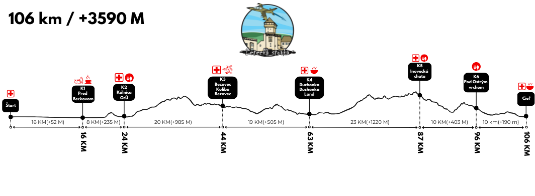
ROUTE
The main section of the Letecká stovka route runs through the Považský Inovec mountain range, while the final stretch—leading from Mníchová Lehota via Macková, beneath Čiernachov, and past Chata pod Ostrým vrchom—lies within the Strážovské vrchy mountains. The start and finish are located in the town of Trenčín.
With the exception of the opening section to Beckov (which largely runs parallel to the Váh Cycling Route) and the final stretch leading to the finish line in Trenčín, the entire Letecká stovka route follows marked hiking trails. The 2027 Letecká stovka route will be ITRA-certified.
The event organizer reserves the right to modify the route and the time limits for checkpoints. Registered participants will be notified via email of any such changes.
Course parameters based on ITRA certification:
106 km (course length) / +3,590 m (total elevation gain)
GPX download
Route details by hiking trail marker colors:
Custom marking:
Trenčín, near the ARENA Ostrov building at Na Ostrove 363 => right across the bridge to join the river embankment => along the Váh Cycle Route (except for detours near the village of Krivosúd-Bodovka and before the village of Beckov)
Green trail marker:
Junction where the Váh embankment path meets the green hiking trail (turn left) => Beckov
Blue trail marker:
Beckov => Kálnica => Piesky => Nad Izbou => Pod Ostrým vrchom
Red trail marker:
Pod Ostrým vrchom => Sedlo pod Panskou Javorinou => Pod Prieľačinou => Zľavy => Sedlo pod Skalinami => Sports Cottage => Bezovec, recreational center => Bezovec, bus stop => Gamekeeper's Lodge below Kostolný vrch
Blue-marked trail:
Gamekeeper's Lodge below Kostolný vrch => Nový majer => Dolina (cottage area) => Holé brehy Saddle => Úhrad => Podhradie (cottage area) => Podhradie
Yellow-marked trail + custom markings:
Podhradie => approx. 500m from the signpost (turn-off to Podhradie): turn left onto the meadow => After the meadow, turn left onto the road towards K4 Duchonka Land => From K4 Duchonka Land, continue straight through the cottage settlement to the end of the road at the junction with the blue-marked trail
Blue-marked trail + custom markings:
At the junction, turn left and follow the blue-marked trail => Duchonka => Turn-off to Nemečky (the initial 700m section follows the "Duchonka - Kulháň Forestry Educational Trail") => Kulháň => Panská Javorina => Saddle below Panská Javorina
Red-marked trail + custom markings:
Saddle below Panská Javorina => Below Ostrý vrch => Tri boky => Above Studnice => Inovec => Below Inovec => Cottage below Inovec => Mníchova Lehota, train station => Cottage below Ostrý vrch => At the signpost, turn left and go uphill towards the small cottage below Ostrý vrch (K6, approx. 80m) => Return to the "Cottage below Ostrý vrch" signpost => Turn right, follow the road (approx. 100m), then turn left onto the red-marked trail => Soblahov => Brezina Forest Park => Atrium beneath the Town Tower => Sládkovičova Street (turn right under the Town Tower) => Mierové Square => Zlatá Fatima => Underpass beneath Hasičská Street => Mládežnícka Street => Turn left onto the cycle path => Old Railway Bridge – Váh Cycle Route (002, N5301) => Trenčín Municipal Swimming Pool => Turn left across the bridge onto Mládežnícka Street => Arena Ostrov Zamarovce, Na Ostrove 363 (Finish)
Refreshment and Checkpoints:
Six refreshment stations offering food and drinks will be located along the route. These locations will also serve as checkpoints where times will be recorded using an electronic timing system. A list of these stations—including their locations, distances from the start, and time limits—can be found below.
FINISH:
The finish line for the Letecká stovka is located in Trenčín at the ARENA Ostrov building (Na Ostrove 363). The total time limit to complete the Letecká stovka course is 25 hours (until 7:00 AM on Sunday, March 7, 2027).

POSITION (K-POINT)
DISTANCE
Start: Trenčín
K1: Pred Beckovom
K2: Kálnica (ObÚ)
K3: Bezovec (Koliba)
K4: Duchonka (Land)
K5: Inovecká chata (cottage)
K6: Chatka Pod Ostrým vrchom (cottage)
FINISH: Trenčín
0 km
16 km
23 km
43 km
63 km
85 km
95 km
105 km
TIME LIMIT (CUT-OFF)
06:00 (Saturday)
08:45 (Saturday)
10:30 (Saturday)
16:00 (Saturday)
20:30 (Saturday)
01:00 (Sunday)
04:00 (Sunday)
07:00 (Sunday)